
Each camera took a half-panorama from the horizon to the sampling area, so the sampling area was seen twice for stereo mapping. If a rock was in the way I think the arm could move a little to the left or right to avoid the obstacle. Why did we not see the pictures? NSSDCA points out they landed 60 hours after sunset, so not much to see! But they were taken and transmitted anyway, probably just to test the system. But what about Earthshine? #moon #Luna16
Not much was said about this at the time, but more recently we have learned that the pictures did in fact reveal some details. Apparently, bright glints off rocks could be seen faintly, but the image quality was too poor for them to be useful. That's too bad. I think that if we could get the original data off the big data tapes (which would almost certainly be in the Lenin Library), modern image processing could probably salvage something from them. #moon #Luna16
But why land in the dark? I note that they spent 3 days in lunar orbit before landing, so they arrived in orbit before sunset. Maybe there was just not enough time to check everything before sunset and be ready to land. Tracking during those 3 days helped improve knowledge of mascons, the gravity anomalies which complicate low orbit operations. But we don't really know why this happened the way it did. I close with another site map and a closeup LRO image composite. #moon #Luna16
Luna 16 was followed by Zond 8, the last test flight of this type of spacecraft. It followed the pattern of a flight around the Moon and back, not going into orbit (like Artemis 2, not Apollo 8 and 10). NSSDCA provides a few details:
https://nssdc.gsfc.nasa.gov/nmc/spacecraft/display.action?id=1970-088A
The photography was much better on this mission with large images taken of a full disk and a lower altitude strip of the farside highlands. Don Mitchell has a good selection:
http://mentallandscape.com/C_CatalogMoon.htm (halfway down). #moon #zond
Kira Shingareva came to Houston one year with CD-ROMs of scanned Zond 8 images. A set went to LPI, I got a set, there may have been others (I was her driver and guide on that trip). The scans revealed something interesting: the images were good quality but had a few scratches. They had not been protected as well as Apollo negatives were (after being developed they were copied and the originals archived for decades with all work done on copies). Only recently were they scanned again.
#moon #zond
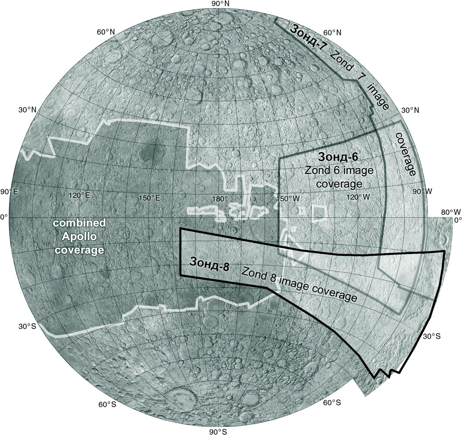
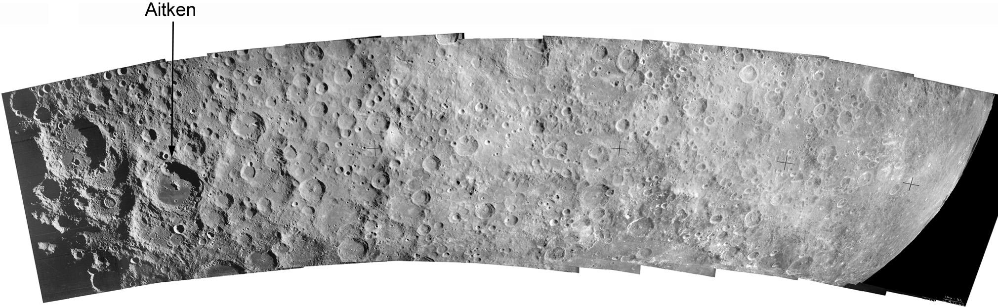
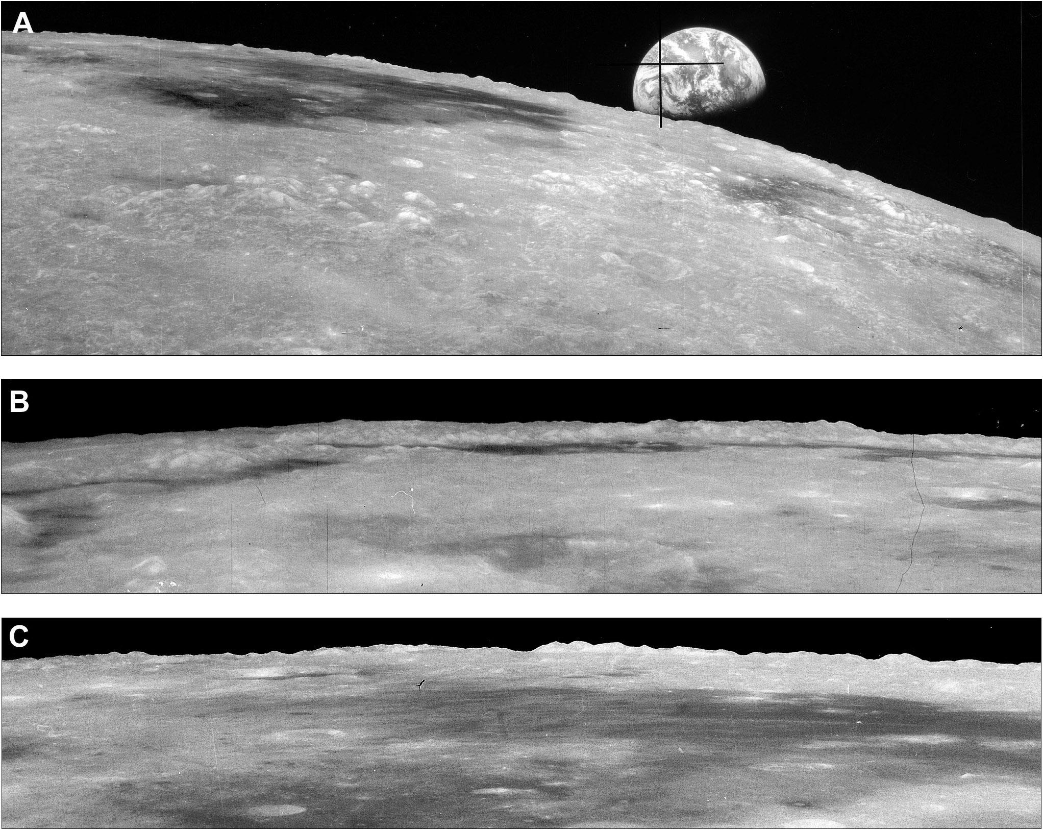
This map shows the Zond 8 image strip coverage, the Zond 6 and 7 image areas, and the Apollo image coverage (omitting only Apollo 13 and the global views taken during departure). Soviet planetary geologists made a nice set of maps of the Zond 8 area with relief drawings and a geological interpretation. Until LRO these were the best images of that region. A limb profile gave another look at topography in the South Pole-Aitken basin (see Zond 6 notes). #moon #zond
Now we move on to one of the triumphs of Soviet lunar exploration, Luna 17 and its companion, Lunokhod 1, the first remotely operated rover on another world. Its mission is briefly described here:
https://nssdc.gsfc.nasa.gov/nmc/spacecraft/display.action?id=1970-095A
(but its comment on cameras is wrong). As usual Don Mitchell has a great set of images here:
http://mentallandscape.com/C_CatalogMoon.htm
(also for Zond 8).
And more panoramas here:
https://www.planetology.ru/panoramas/lunokhod1.php
There is plenty to look at here. Tomorrow... where is it?
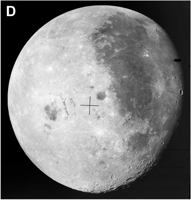
This is the region where Luna 17 landed with its precious cargo, Lunokhod 1. It's at the western edge of Mare Imbrium where it merges with Oceanus Procellarum, and not far from the Gruithuisen Domes where a CLPS mission will be heading next year. The early landers were sent to western equatorial sites (for a relatively easy vertical descent) and the sample return missions to the east as mentioned earlier. Lunokhods went to northern mid-latitude sites. Why? #moon #luna17 #lunokhod1
I have never seen a reason for the Lunokhods to go to northern mid-latitudes. Is it fair to generalize when there were only 2? There was actually a third, lost in a launch accident in February 1969, which was apparently supposed to go to the Lunokhod 2 site which we will see later. I suspect the mid-latitudes were chosen for their mid-day temperatures (lower than at the equator) which would matter for these long-lived missions. All 4 Chinese landers have done the same. #moon #luna17 #lunokhod1
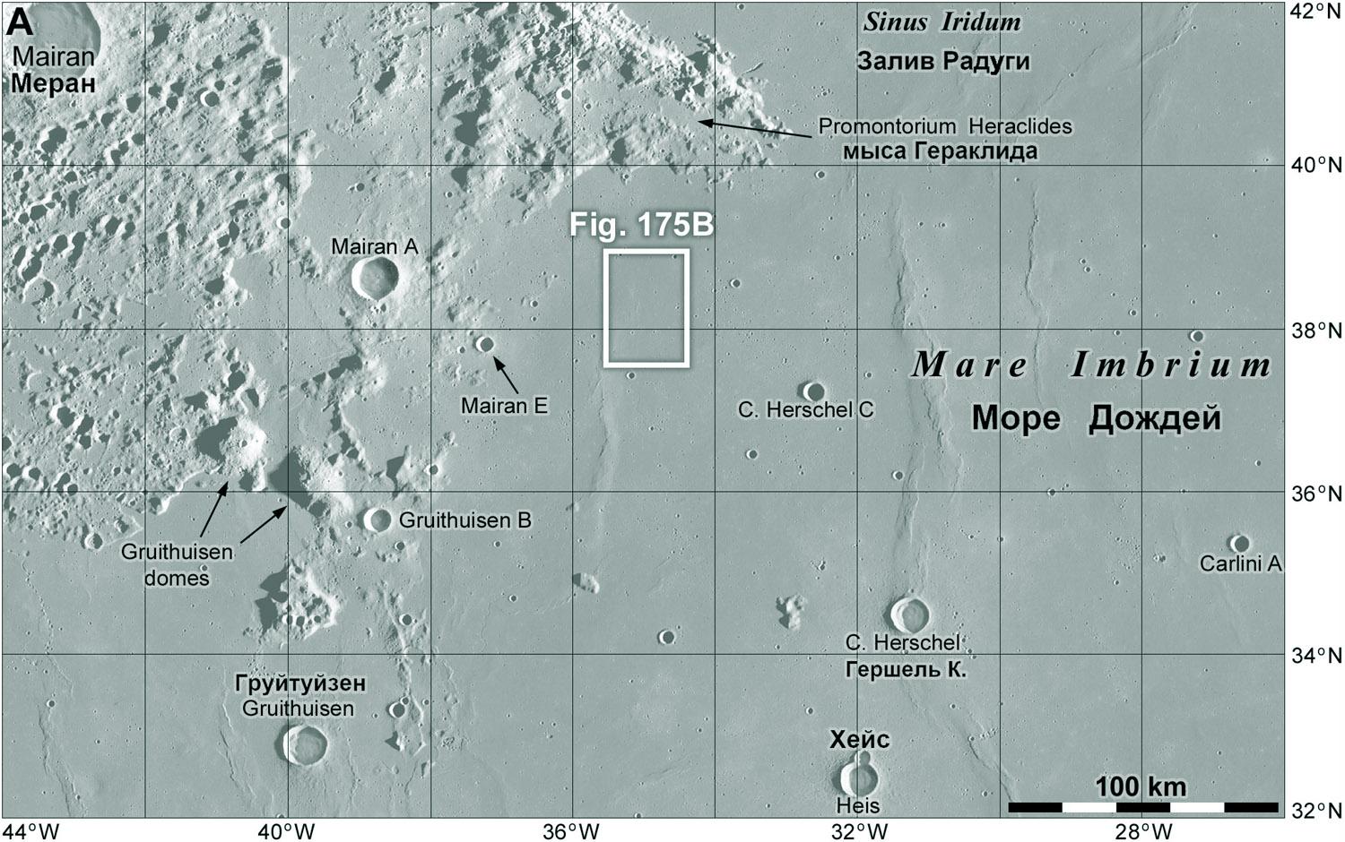
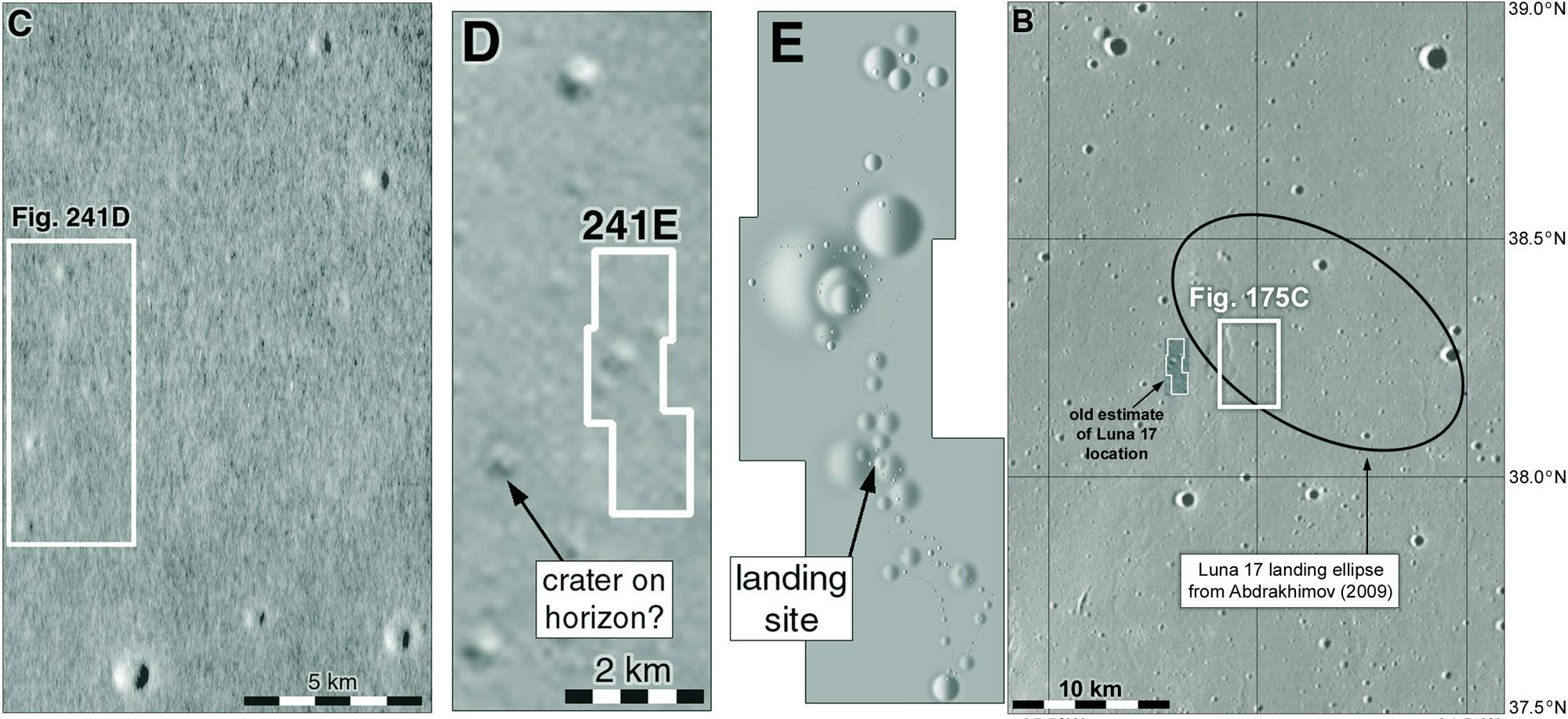
My last map has a box labelled 'Fig. 175B'. Just a reminder that these are placeholders for figure numbers in a future project which I will be talking about later in the year.
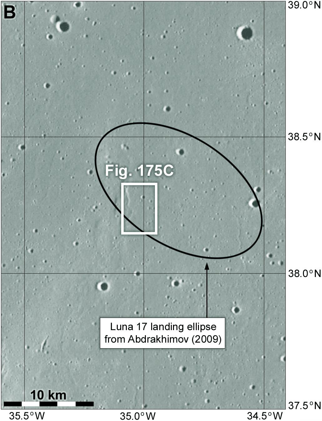
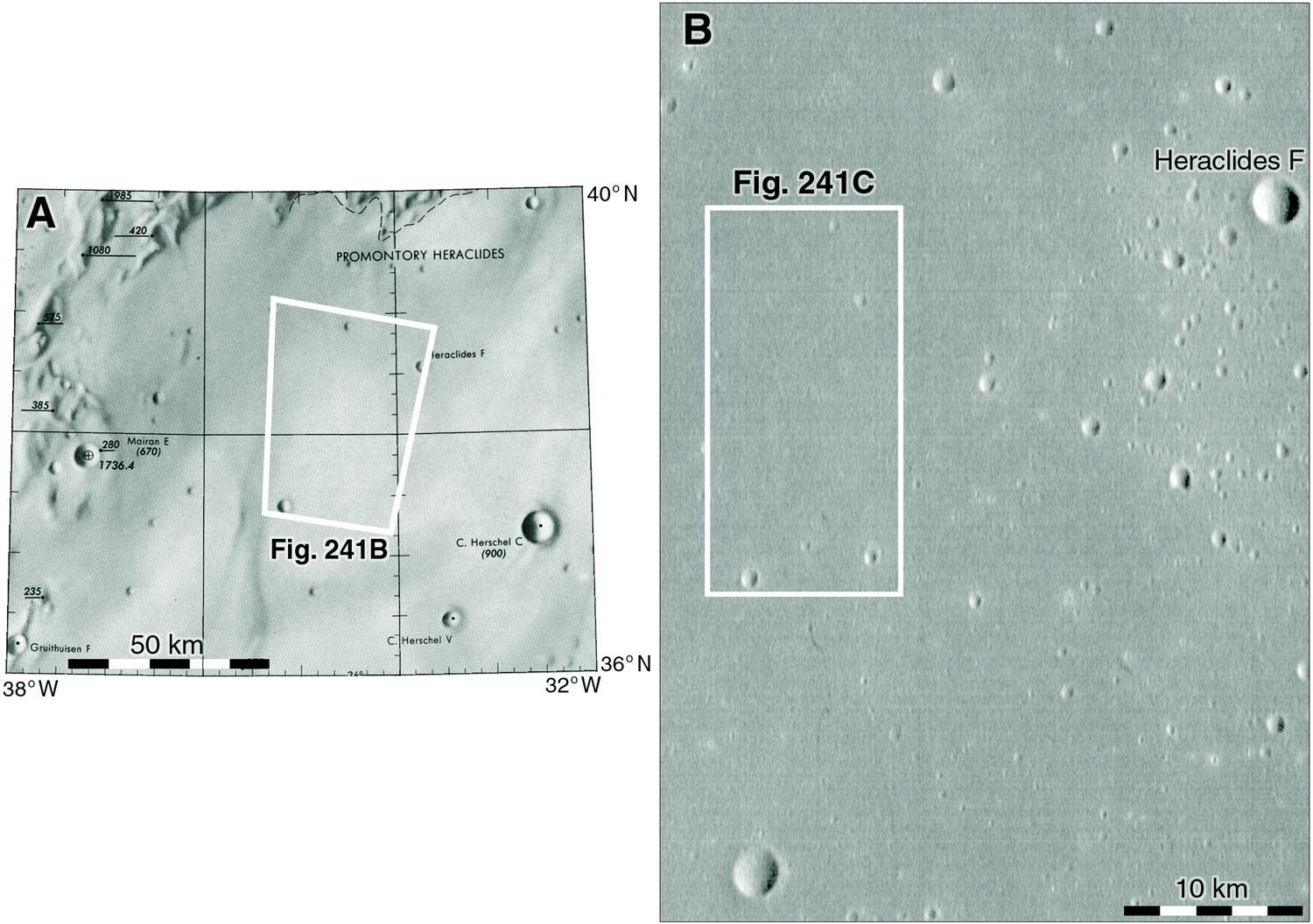
Let's zoom in on that boxed area. This map shows the landing ellipse shown in a 2009 publication. A smaller box zooms in towards the landing site. A wrinkle ridge is just visible within it.
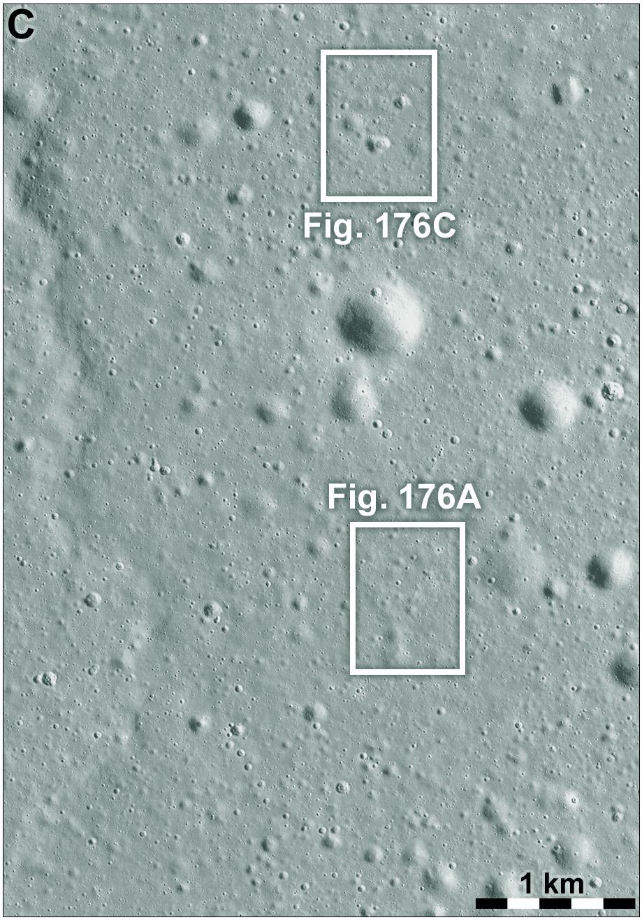
Zooming in again we see the ridge very clearly. I will have something to say about it soon. Among the scattered craters are two more boxes. The lower one shows the position of the lander. The upper one shows the final resting place of the rover. I make sequences of maps like these so people can easily find a small spacecraft in a large image (LRO NAC images are 50,000 pixels long and 5000 pixels wide, that's a lot of pixels to search through).
#maps #moon #luna17 #lunokhod1
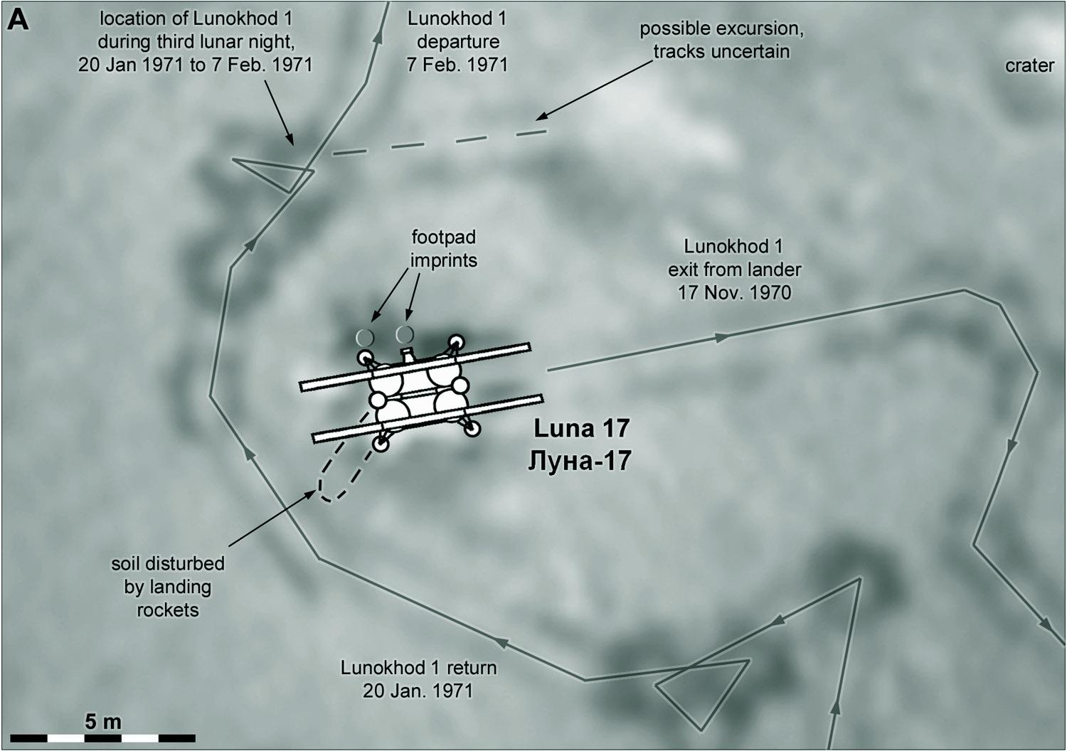
Finally that zoom-in sequence leads to this. Box A in the previous post refers to A here, which takes us to B with the lander itself. Box C in the previous post refers to box C here and the link to D, the rover's final parking place. Tracks from Lunokhod's wheels are visible around Luna 17 and the parked rover. We will be following the traverse in a set of maps like the Apollo EVA maps. But first, let's consider how we know where Luna 17 landed. #maps #moon #Luna17 #Lunokhod1
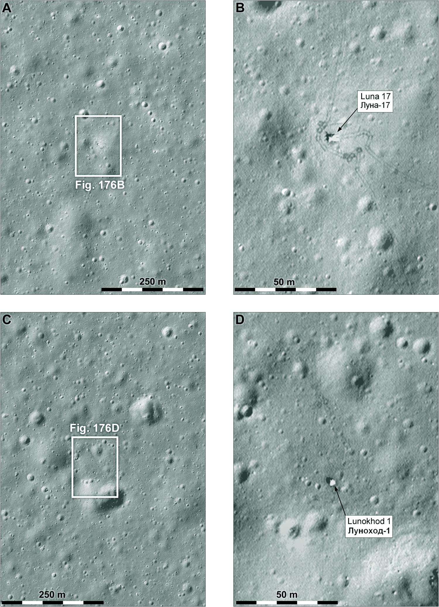
Now it's very clear where Luna 17 landed. we have LRO images good enough to show the lander and rover and the wheel tracks. But what did we know before LRO? My first Moon atlas came out before LRO (so it was swiftly rendered out of date and some of my speculation was shown to be wrong). This illustration shows what I thought about the landing site in about 2005 when I was doing that work. Tracking and orbit data gave us a position accurate to within about 10 km. #maps #moon #Luna17 #lunokhod1
Here we zoom in more. C is the best image we had, an Apollo 15 oblique Hasselblad photo, roughly rectified. Another clue came from a Soviet Lunokhod 1 route map which showed many craters. Image E is a shaded relief depiction of those craters. D was my attempt to match E with C. You can see how hard it would be to get it right. As an extra bit of the puzzle I thought a very subtle feature on the horizon in a Lunokhod 1 image might be a crater rim. #maps #moon #Luna17 #lunokhod1
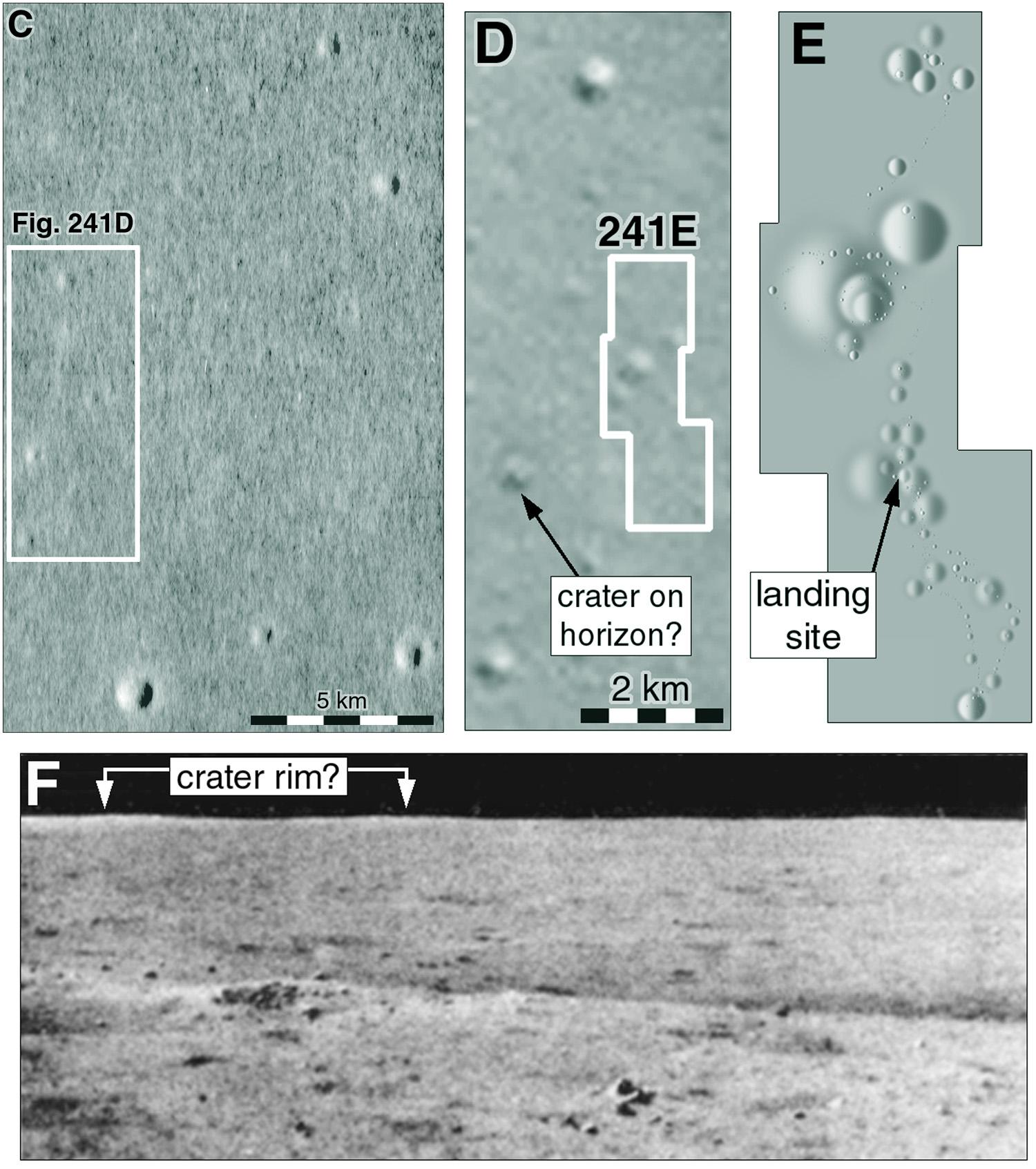
Here is that Soviet-era map. My shaded relief version, based on this, shows a large crater near the middle - the largest one in the map. Naturally I tied to match it to the orbital data. But it doesn't really exist if you check the LRO data, so I can use that as an excuse for not getting it right. Maybe it was a very subtle depression rather than a distinct crater. #maps #moon #luna17 #lunokhod1
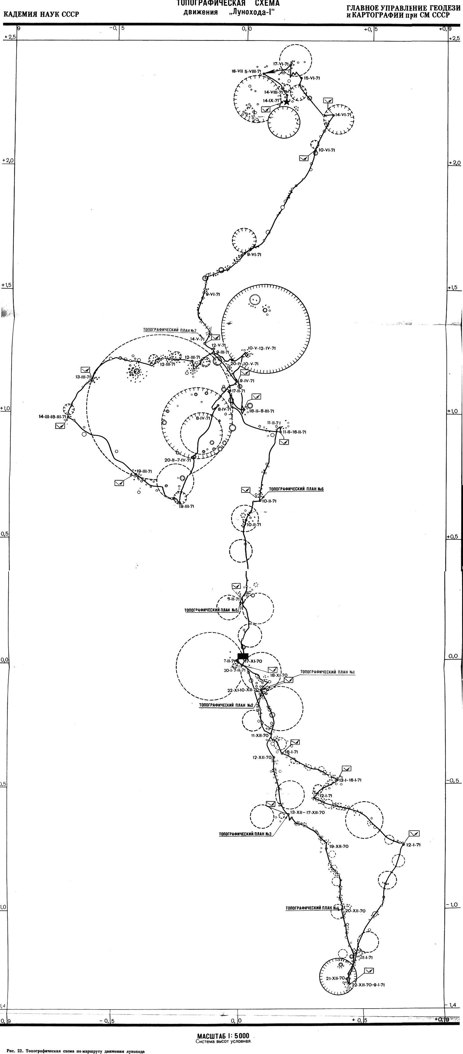
I was distracted last night by current events on the Moon. Continuing our story of Soviet lunar missions, we were looking at where Luna 17 might be. There is one more bit of information about the location which we have not considered, but I will come back to it later. So on with Lunokhod 1. I will show the traverse in a series of maps like those we saw for Apollo, and this map serves as an index to them. Figure numbers refer to a future project. #maps #moon #luna17 #lunokhod1
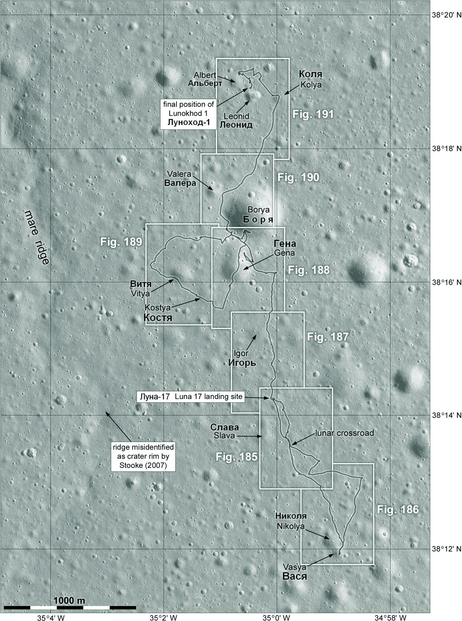
A few things to say - crater names were not used at the time but come from a new Russian map and are official. They are people associated with the mission. The ridge at left is perhaps what I saw as a crater rim. Notice the lat-long labels are degrees and minutes. Usually I use decimal degrees but my policy has been to match contemporary documents. But looking at this, I have decided to change back to decimals (later). #moon #luna17 #lunokhod1
This map is the first one covering the Lunokhod 1 traverse. The previous map is an index to this set. This map shows both a drive to the south from the lander and part of the return journey. Dates are from the Soviet original posted recently. The 'plan' labels refer to places where multiple images allowed for detailed mapping of areas of interest, and they will be shown later. See the note about laser detections. We will come back to that. #maps #moon #luna17 #lunokhod1
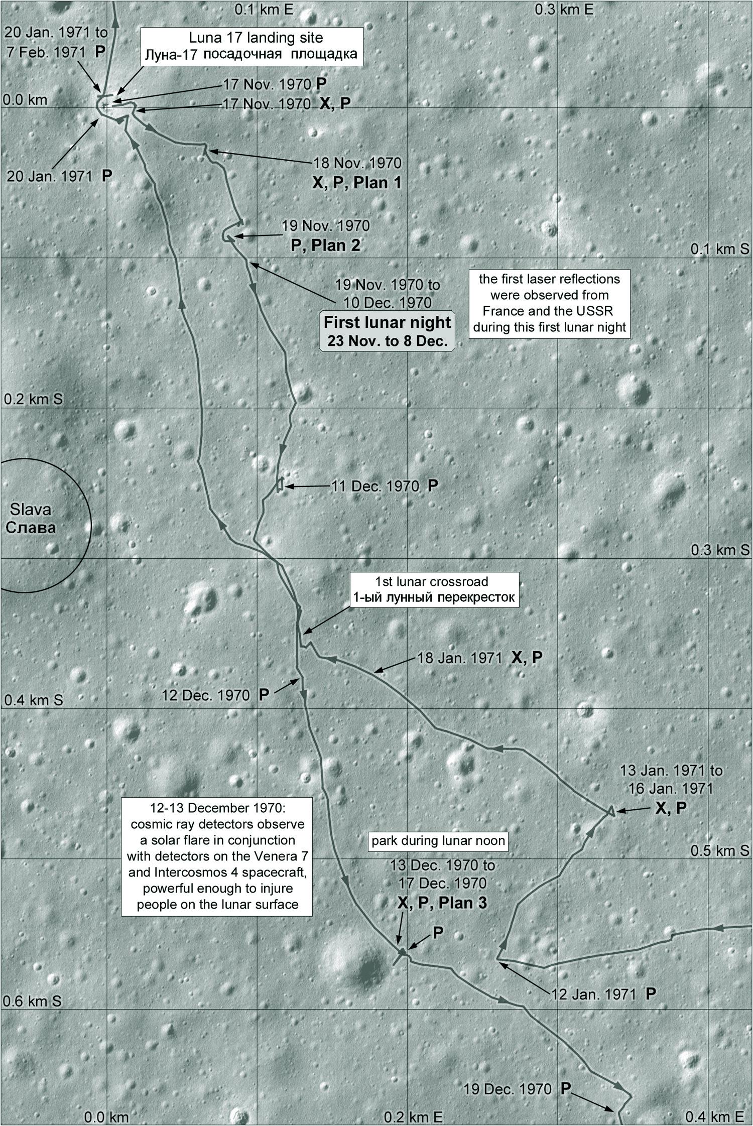
The letter P symbol on the Lunokhod 1 map shows where panoramic images were taken. The X symbol shows where the X-ray surface composition instrument was used. If you follow the dates carefully you will see that Lunokhod started work a day or two after sunrise, operated for just a few days, then took a nap over the middle of the lunar day (e.g 13-17 December), drove for a few days and shut down a day or 2 before sunset. China's Yutu rovers did the same.
#moon #luna17 #lunokhod1
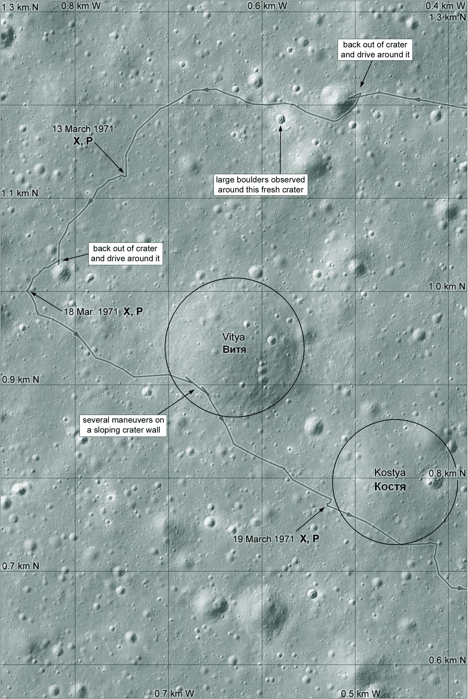
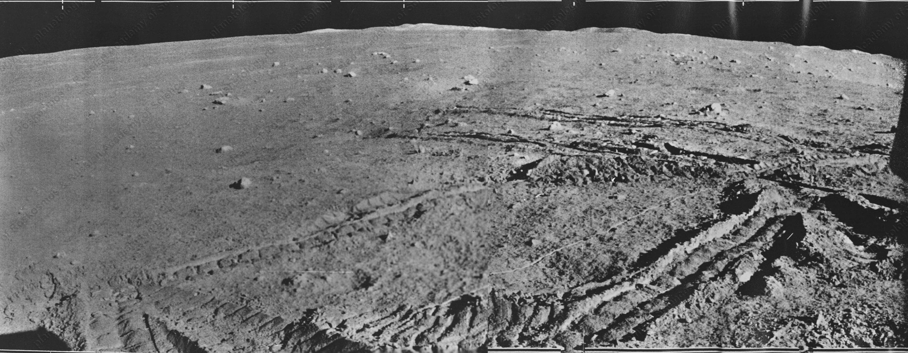
This is the second Lunokhod 1 map, the southern end of the drive. The first lunar night was spent not far from the lander. The second was at the southern point here. On the third day the rover was driven quickly back to the lander, testing navigation. Remember they were driving effectively blind. There were no great images like these we have now. Just being able to get back to the lander quickly was an accomplishment. #maps #moon #luna17 #lunokhod1
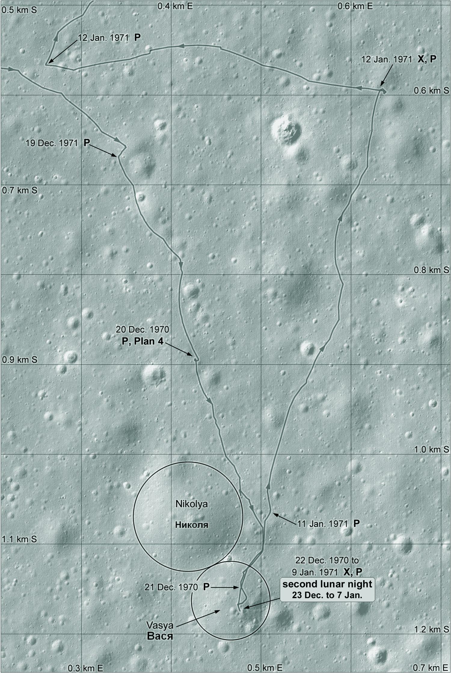
Lunokhod 1 spent its third night close to the lander - there wasn't room to label it on the first map but here it is made clear. The lander was imaged from several directions. Then the rover drove rapidly northwards. The mission team had spotted distant hills on the northern horizon and decided to head for them, not to reach them but at least to get a closer look. We'll get to that later. #maps #moon #luna17 #lunokhod1

We come to the 4th map of the Lunokhod 1 mission traverse, and there is quite a lot to say about it. The rover was driven north on the morning of lunar day 4 and paused for a few days around lunar noon in mid-February. Then it moved northwest to a spot on a crater rim on 18 February, turned back and stopped for the night on the 19th. On day 5 the rover drove a loop to the west, which runs into the next map, and back into this one.
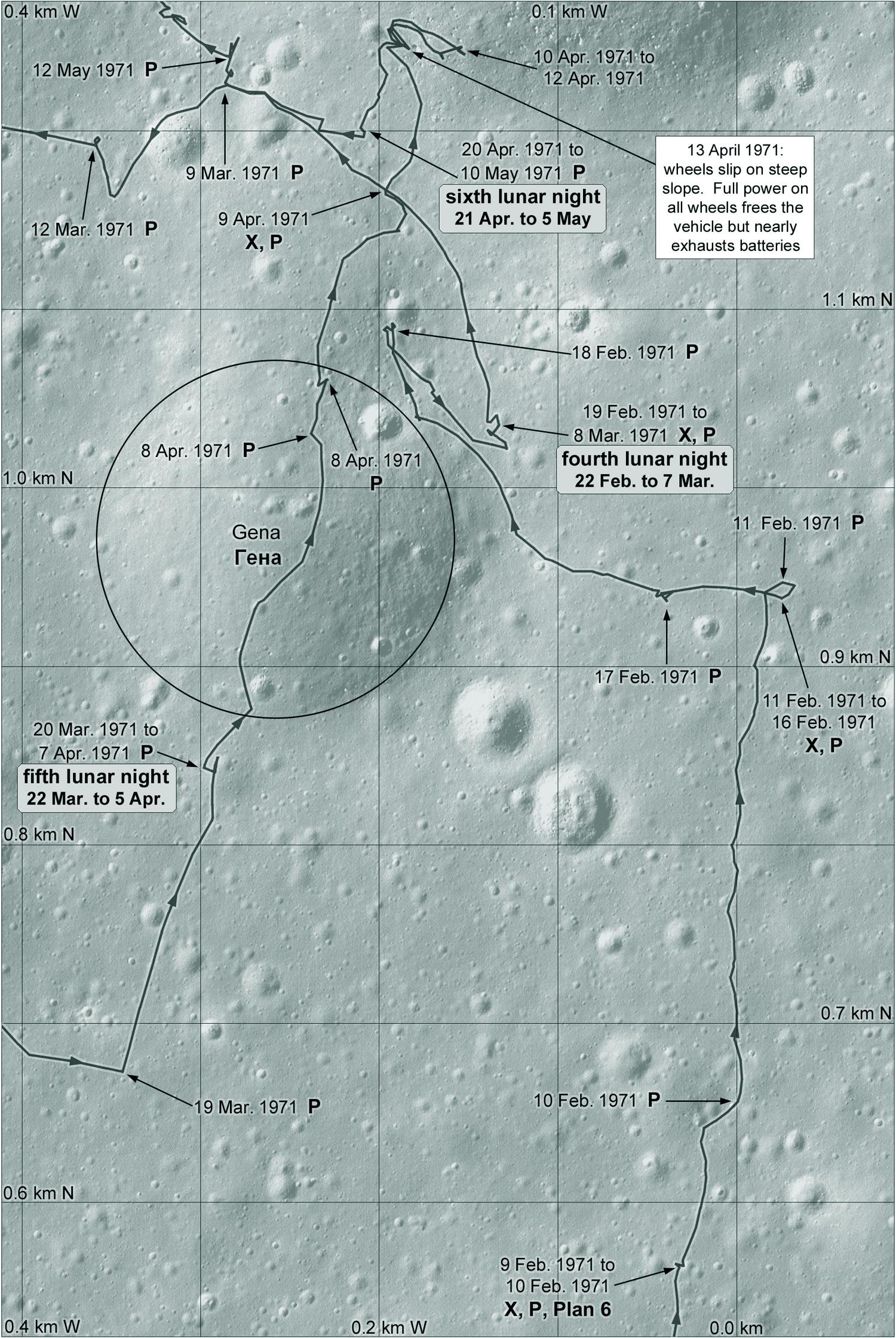
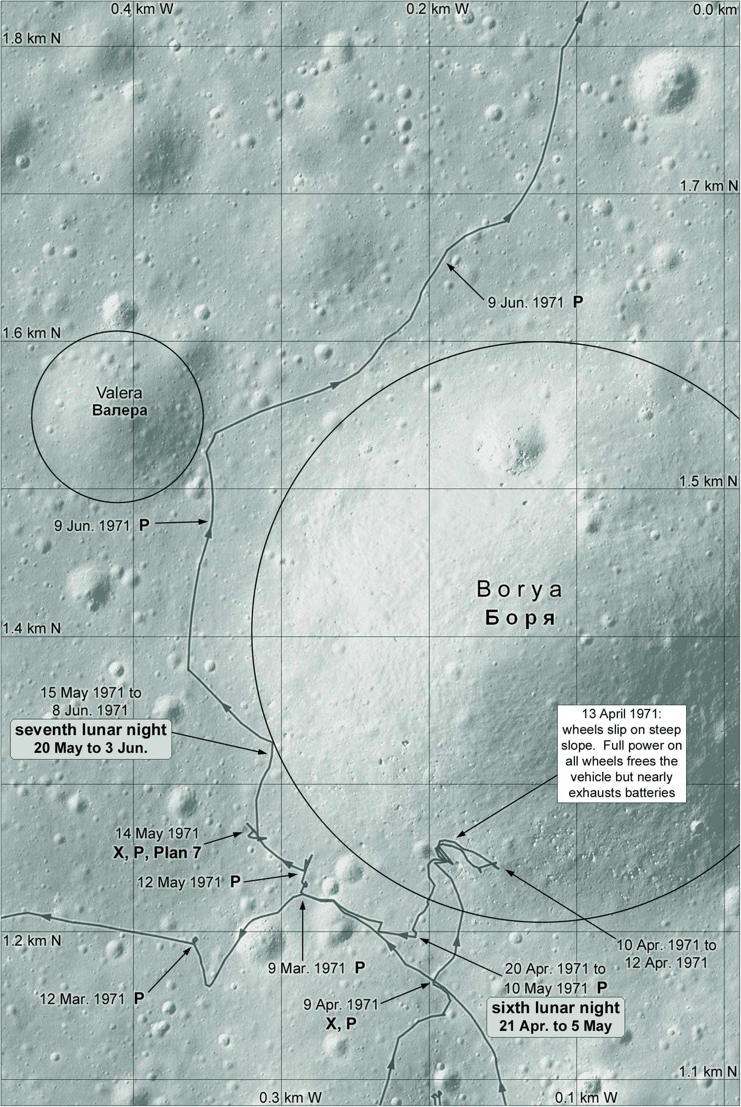
After that westward loop Lunokhod 1 drove on day 6 through the shallow crater Gena and into Borya, the largest crater. It had trouble getting out and stopped to recharge. On lunar day 7 it drove north again, around Borya.
Just after the 4th night, on 8 March... well, that is International Women's Day, a holiday in the Soviet Union. The rover team promoted a figure 8 made by the rover's wheels (two adjacent turns in place) as a memorial to women for that day... #moon #luna17 #womensday
... This story about Women's Day is also told about a marking made by Lunokhod 2, but the mark in question was made about 2 months before the day that year.
Where is this? As far as I can tell it's this marking. And I think it was made at that point I mentioned on 18 February. That was only an Earth day before the rover stopped for the night, easy to remember on the next morning. Enjoy the day this year with a special person (advice does not apply in the US).
Today we see the fifth map of the Lunokhod 1 traverse. This is the big loop to the west of the previous map. It only took a few days. Compare this map with the Soviet traverse map I posted earlier. This loop was mapped as if it roughly followed the rim of a large subdued crater. Looking for that crater - which doesn't really exist - took up a lot of my time and gave me an incorrect location before LRO found the site. #maps #moon #luna17 #lunokhod1
After that loop Lunokhod 1 returned to the vicinity of Borya crater, and it is now that it enters the crater. That may have been a mistake, and it was certainly hard to get out. The rover had to use full power to escape the steep slope, running down the battery. When it was back on level ground it rested to recharge and then went into its sixth night. It didn't go far in day 7 and spent the next night on the rim of Borya. #maps #moon #luna17 #lunokhod1
This is the 7th and final map of the Lunokhod 1 traverse. The rover was driven north from the previous map area and into a cluster of craters, some of which were given names. It reached its northernmost point on 17 June and parked for the 8th night nearby. Systems were apparently deteriorating and the next day saw only a short drive near Albert crater. The next lunar day, the 10th, was also marked by short drives and many twists and turns. #maps #moon #luna17 #lunokhod1
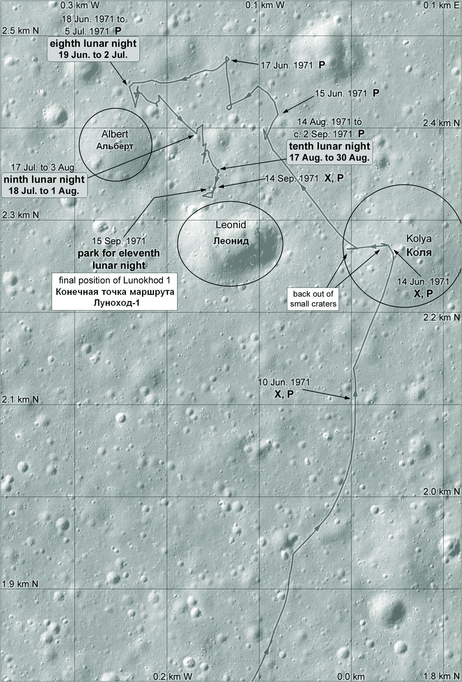
The last day, the 11th, saw the rover stop just north of a crater called Leonid. Next we will look at the 'plan' areas noted on the maps and the actual landing site.
This is the immediate area of the Luna 17 landing site showing the paths of the rover around it. Lunokhod 1 departed on the east side, and after its excursion to the south it returned and drove around the lander, parking northwest of it. The dark rings are made by in-place turns, visible in LRO images. Some of the moves are to provide overlapping panoramas for stereo viewing. The footpad imprints and disturbed surface are visible in rover images. #maps #moon #Luna17 #lunokhod1
The first map of the Lunokhod 1 traverse included two areas marked Plan 1 and Plan 2. These are the plans - maps, in other words. They were made using several panorama images to form stereoscopic pairs and the originals included contour lines as well as small crater outlines and rocks. I made a shaded relief interpretation of each plan. The plans appeared in Vinogradov, A. P., 1971. Peredvizhnaya laboratoriya na lune Lunokhod-1. Moscow: Nauka. #maps #moon #luna17 #Lunokhod1
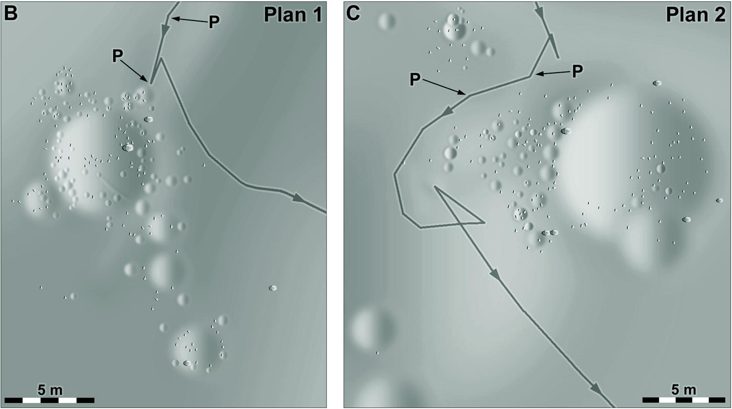
While I was working on those shaded relief drawings I was comparing the panoramic images with the plans, and I discovered one or two places where the panorama just could not be made to fit the plan... until I noticed the panorama was printed in reverse (as if a negative had been flipped over). That got me into no end of trouble. Once seen it could not be un-seen and I suspected reversed images everywhere, leading to some very silly mistakes, mainly with Lunokhod 2.
I should have mentioned that the Vinogradov reference comes in two volumes. There was no corresponding publication for Lunokhod 2, alas.
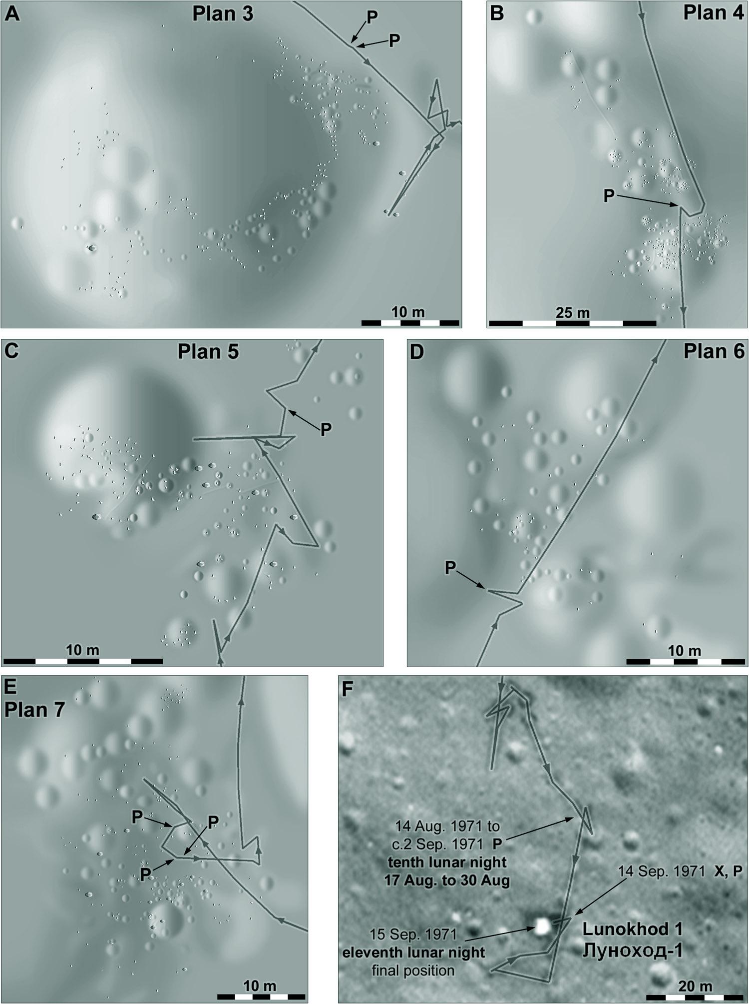
Here are the remaining plans from Lunokhod 1 images, and a final map of the end of the traverse derived from LRO images of tracks and the old Soviet map.
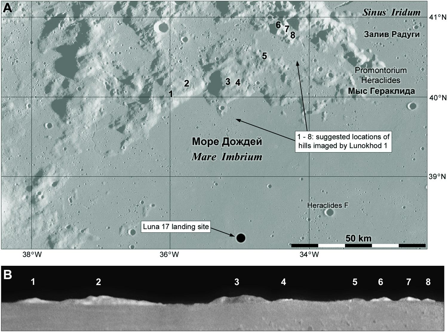
This link goes to a Lunokhod 1 panoramic image taken on lunar day 9:
https://www.planetology.ru/panoramas/images/big/lunokhod1_c/L1_D09_S02_P04m.jpg
And here is part of it showing hills on the northern horizon (credit: Roscosmos and the Russian Academy of Sciences).
They are the only distant features visible at this site. Can we identify them? (Spoiler... yes!)
Here I show the hills at the bottom - a composite of all available images of the hills to ensure maximum coverage and improved signal to noise. The map above shows the locations of the various peaks - the small eastern ones are less certain than the larger ones.
The Moon has been keeping me busy lately, but I'm back on the job. That view of the northern horizon showing distant hills can be replicated using synthetic panoramas made in Quickmap:
(https://quickmap.lroc.asu.edu).
Here is a panorama made at the Luna 17 location but at an elevation of several hundred meters, so it looks a bit further over the horizon. There are hills in other directions not seen by Lunokhod 1. #moon #luna17 #lunokhod1
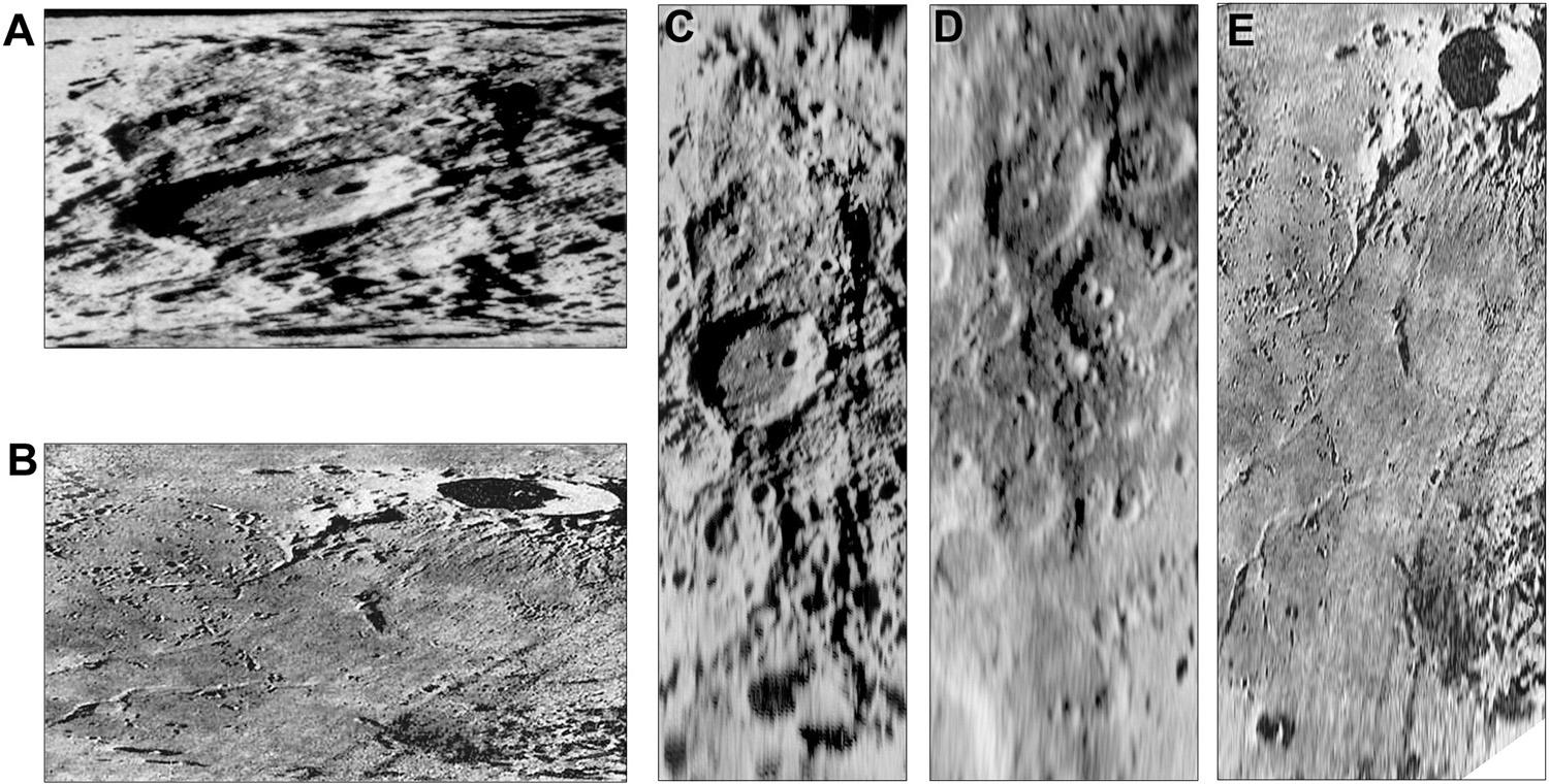
There is one other thing I want to say about Lunokhod 1. I will start by combining two posts from earlier in this sequence. This image shows 3 panels at left illustrating my old guess about where Luna 17 landed (best image at the time, from Apollo 15; a map of the traverse area showing craters on the old Soviet map, and between them, where I thought that map fitted on the image. At right is a context map for my later maps, with the old outline added.
#maps #moon #luna17 #lunokhod1
The significant thing to take from this is that I was about 6 km too far west. I chose that spot because it was the only place where there seemed to be a pair of craters matching the largest two in my relief map. As we have seen, the largest one doesn't really exist so I was never going to get it right. In fact, even the biggest crater (Borya) in the traverse area is almost invisible in the old image. This became a problem beyond just me being wrong... #moon #luna17 #lunokhod1

To know where Lunokhod 1 was before LRO revealed it, the attempt at matching a map to images is one approach. But there was another - laser reflections. Lunokhod 1 carried a reflector supplied by France. The Vinogradov reference (Vol. 2) summarizes contemporary results, shown here. The ellipse is the spread-out footprint of a laser shot from Earth (footprints are much smaller now). laser shots centred at 1 and 2 gave reflections, but weakly at 3, not at 4. #maps #moon #luna17 #lunokhod1
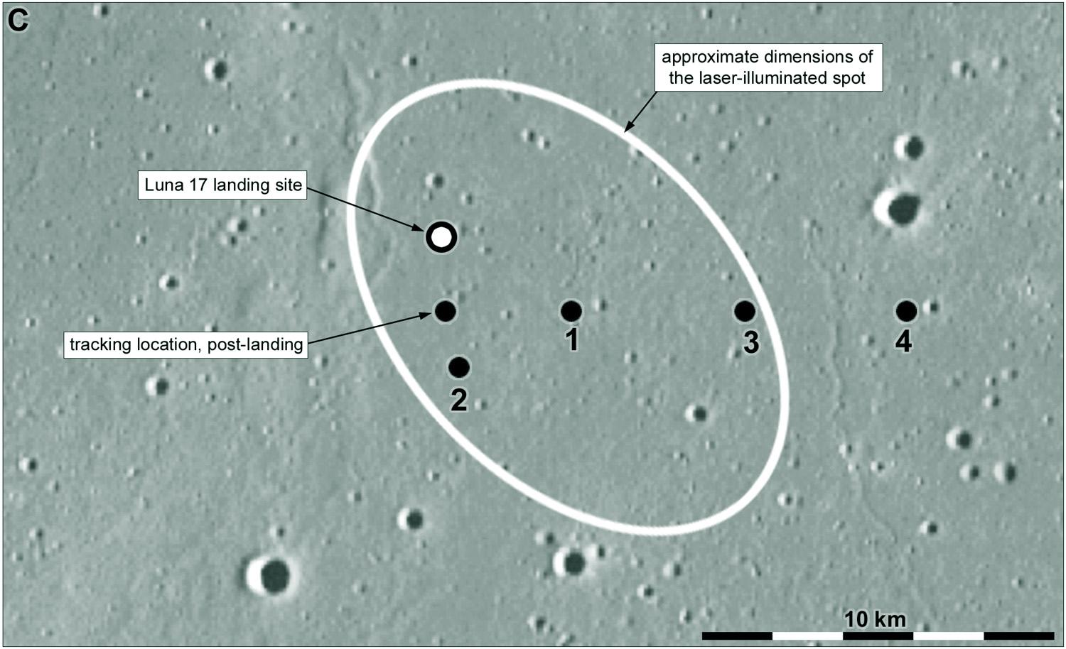
My location for Luna 17 was too far west but was not ruled out by the laser data. Here is my LPSC abstract on it from 2005:
https://www.lpi.usra.edu/meetings/lpsc2005/pdf/1194.pdf
I was contacted by the team trying to get new detections from Lunokhod 1:
https://arxiv.org/pdf/1009.5720
With a small footprint and a very narrow range gate (see the second link) the uncertainty made the reflector very hard to detect, and my error wasted some of their time. Only when LRO found the rover did they succeed. #moon #luna17 #lunokhod1
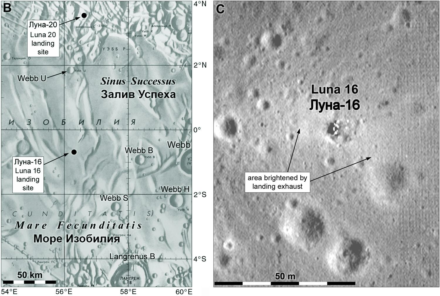
Moving on to Luna 18 now... this was another sample return mission like Luna 16. The area accessible to these sampling missions was very limited and within it was Mare Fecunditatis, sampled by Luna 16, and a highland region north of it which was another obvious target. NSSDCA has a description of the mission here:
https://nssdc.gsfc.nasa.gov/nmc/spacecraft/display.action?id=1971-073A
Things were going wrong during the flight and Luna 18 failed at some point during the landing attempt. Can we find it? #moon #luna18
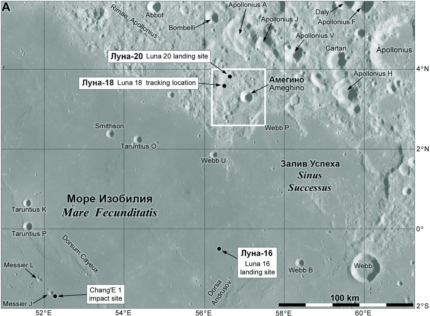
The NSSDCA link yesterday says the Luna 18 impact was tracked to c. 3.57 N, 56.50 E, and that LRO shows a crater which may be the impact site at 3.76 N, 56.66 E.
My map, from Quickmap, shows those locations and Luna 20's landing site. I had not seen the impact crater suggestion until right now when I looked it up for you, dear reader. I think it's a bit too far from the tracking position but not impossible. Let's take a closer look...
#maps #moon #luna18
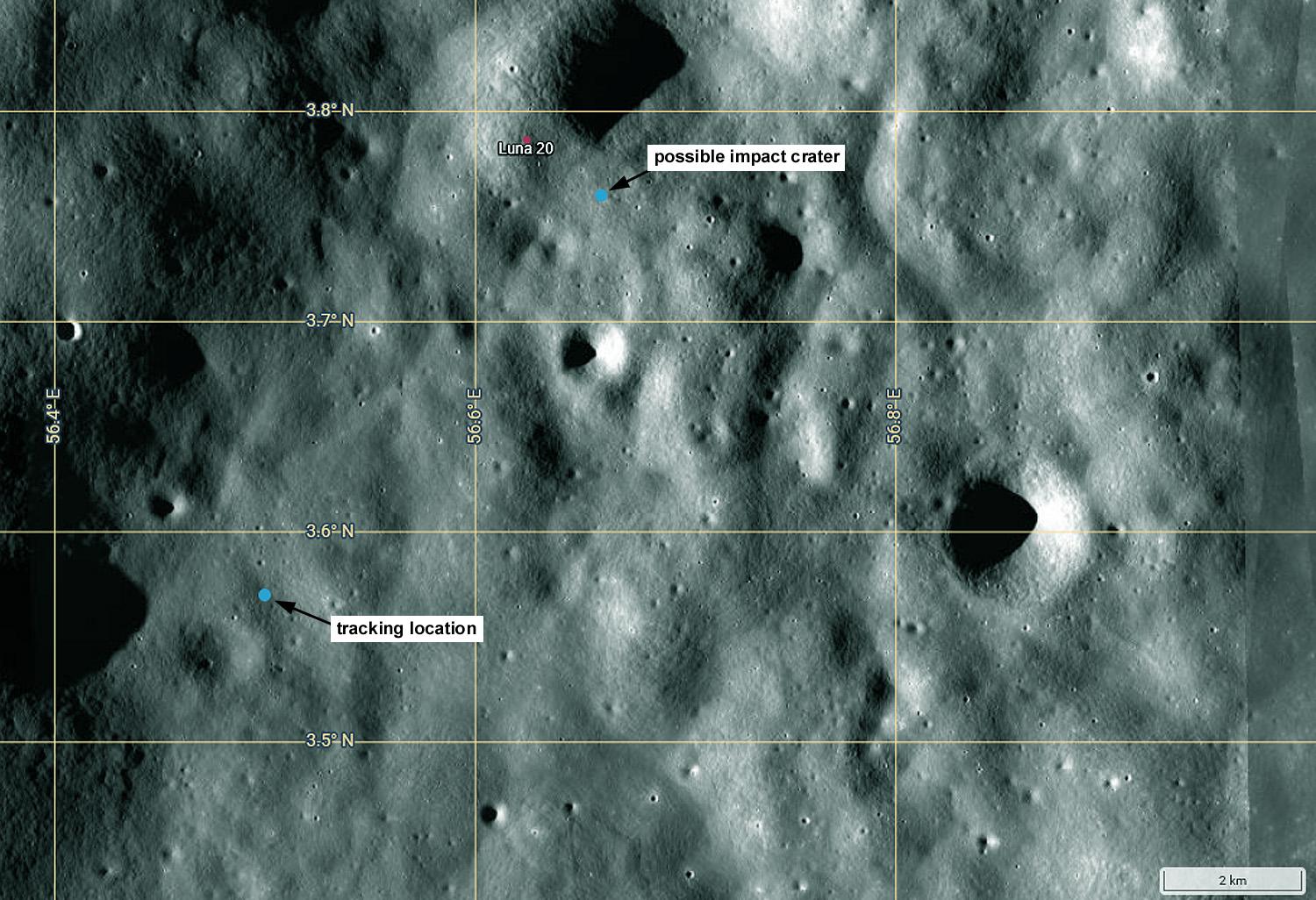
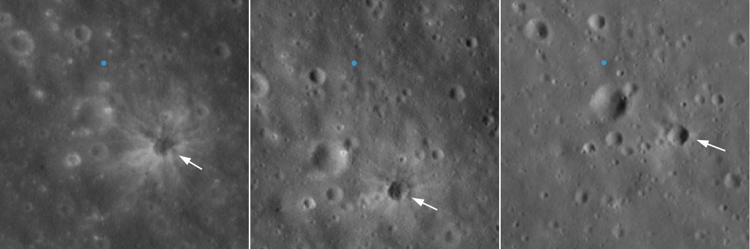
The crater can't be seen in that last map but here I zoom in on it. The blue dot is the indicated latitude and longitude. Note how it seems to move relative to the craters... but this is deceptive. It's the craters which are moving, the point is fixed. Each image (from 3 separate NAC layers in Quickmap) is registered to the coordinate grid differently, illustrating how uncertain coordinates are in this or any other map. But is it the right crater? #moon #luna18
First, the crater is not at the indicated coordinates in any image. The coordinates were probably assigned early in the LRO mission and have not been updated as registration has improved. The crater is about 20 m across. Ranger craters were 10 m across, Apollo Saturn upper stage craters were 40 m across. This might be OK for something coming in fast like those things, but it's too big for something which was braking for a landing So what happened to Luna 18?
There are conflicting stories about Luna 18 (landed on a slope and fell over, ran out of fuel as it descended) but they all seem to agree it was already travelling quite slowly (by orbital standards) as it came in for a landing. Any crater should be small, and it might have landed nearly intact and not made much of a crater, just broken up.
I don't think this can be the right feature, but I have searched for it and not found anything. Another mystery on the Moon!
Next in line is Luna 19. This was an orbiter using the Lunokhod landing platform adapted for orbital observations. We don't know a lot about it. Here is the NSSDCA description:
https://nssdc.gsfc.nasa.gov/nmc/spacecraft/display.action?id=1971-082A
Don Mitchell has some images (near bottom of his page):
http://mentallandscape.com/C_CatalogMoon.htm
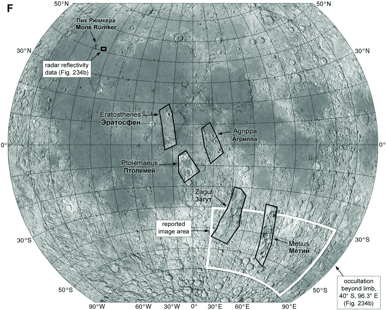
The most reported results are from a camera system, but there were also radar reflectivity (I think this means bistatic radar) and occultation observations probing dusty plasma near the surface.
I looked at all this stuff over 20 years ago for my old Moon book, but now that I am summarizing things here and preparing my new Magnum Opus I am finding new things to update my maps. Tomorrow we can look at what is going on with Luna 19 in more detail.
Let's start with the images taken by Luna 19. The NSSDCA text mentions 2 TV cameras. Don Mitchell calls them scanners (which is correct, though there are hints both systems might have been used). The scan line ran from horizon to horizon and orbital motion moved the scan line along the track. Oddly some images seem to have scan lines diagonal to the ground track. There's a lot we don't know. Only 5 images have ever been released... here are 3 of them. #moon #luna19
Presumably the originals were higher resolution, but how much higher? If really good images were obtained, we would have seen them. The other 2 images are only seen in very low quality prints. There seem to be no publications on the results, leading me to think they were engineering tests of cameras intended for other destinations (Mars 4 and 5 carried modified scanners later). These images were essentially useless for science or landing site selection.
This map shows the areas covered by Luna 19 images. Some reports said they covered an area marked as a white box, but there are others outside it. Luna 19 also made radar reflectivity measurements (upper left) and used a radio occultation to probe plasma above the surface (text at lower right). Those results were published. The radar experiment used the radar altimeter but there's no sign of any actual altimetry being done. A confusing situation!
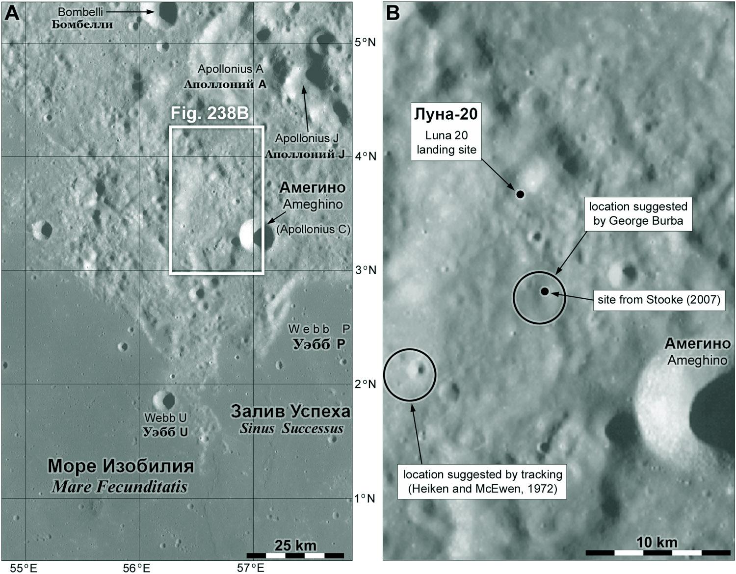
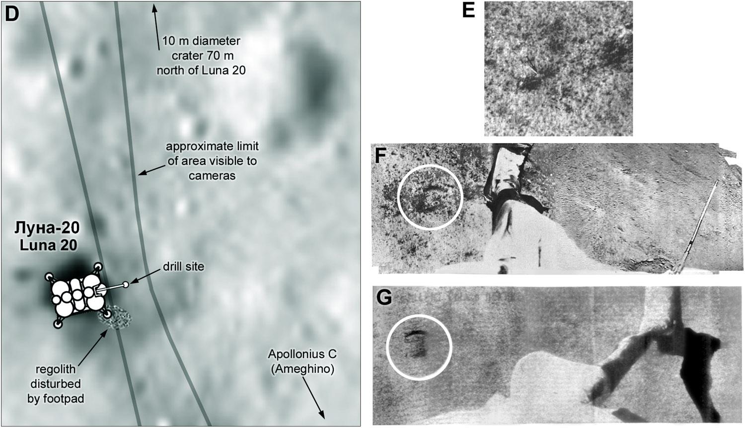
Luna 20 was the next sample return mission, sent to the same location as Luna 18, and this time it was successful. My map shows the region, and a closeup of a broad depression showing a few guesses about where it landed. This was a candidate Apollo 17 landing site as well, and it was specifically dropped because it was an area that a Soviet lander might sample. My old book had a mistaken guess about the site and we will soon see how that happened.
This set of maps zoom in to the Luna 20 landing site. In the last image an object is labelled 'Luna 20'. How do we know this is indeed the lander and not just some rock? First, it's about the right size and shape. But we can do better. Zooming further in (next post) we can see the object more clearly and especially its shadow, which is very distinctive. #maps #moon #luna20
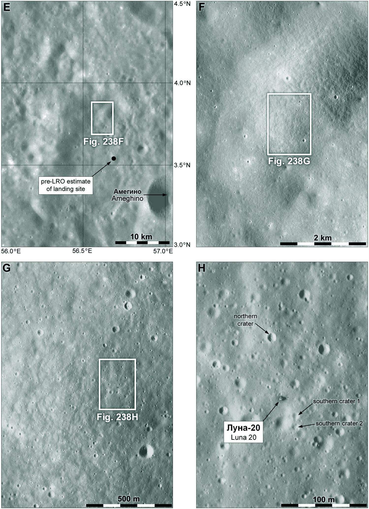
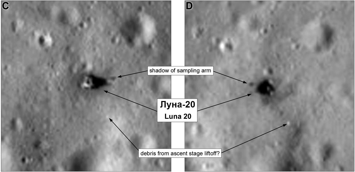
These are two LRO images of Luna 20 with opposite illumination - afternoon on the left, morning on the right. The shadows are both accompanied by a small shadow cast by some object, and it's clearly held high enough for the shadow to appear on opposite sides of the lander. It's believed to the a structure on the end of the sampling arm, which was lifted up high to deliver the sample to the return capsule.
Luna 20 was the only Soviet sample return lander which imaged the surface (Luna 16 did as well, but long after sunset). So we could compare those pictures with LRO images to locate Luna 20. I tried that in my old Moon book but had the orientation wrong and tried to match features in the wrong place. Such is the malleability of the human mind that I made it work anyway (and you thought AI was dumb!) Let's have a look at the pictures. These fragments are all I have seen. #moon #luna20
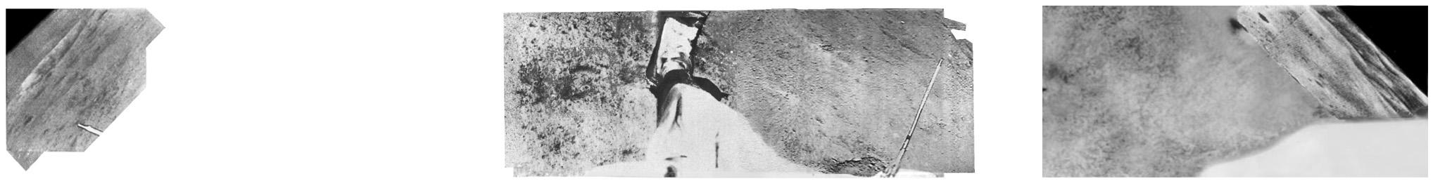
This needs some explaining. First, fragments come from scans made at MIIGAiK in Moscow, and from Don Mitchell and Ted Stryk. Ted has done great work over many years rescuing obscure planetary data - see his work here:
https://bsky.app/profile/tedstryk.bsky.social
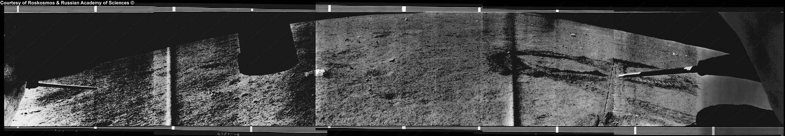
There were 2 cameras, one each side of the drill. Each scanned from the horizon to the foreground. Put them together and you get a full 180 panorama with the foreground in stereo. In the middle is the drill on its arm. #moon #luna20
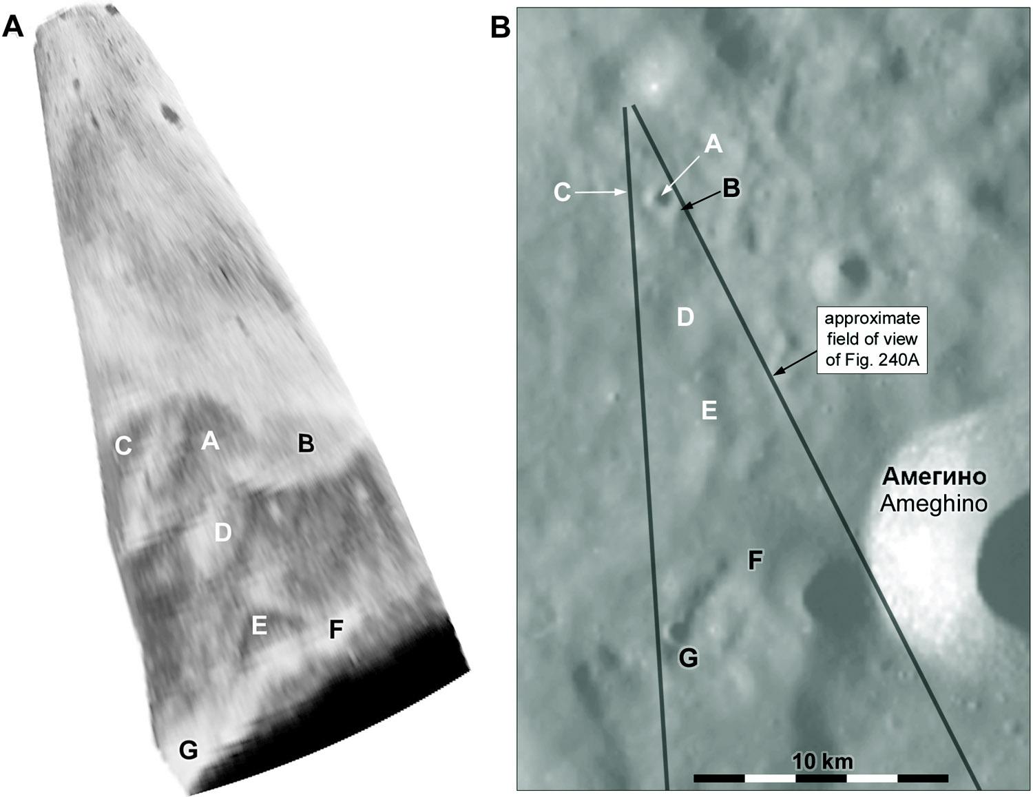
We don't know if the missing parts were imaged, though I expect they were. Ted has assembled these fragments differently, I like to think somewhat artistically, to make a view without gaps, but I think this is more accurate. At far left is a bit of the horizon to the north with a crater ('northern crater' in yesterday's post). At far right is a more hilly horizon. In my old book I thought this was to the east but it's not, it is south of the lander. #moon #luna20
This map shows the approximate area near the lander covered by the camera (not just the small image sections in the panorama as posted). With it are three images of the sampling area. The top image shows the surface before sampling. The other two images (taken by the two cameras, hence the different geometry) show the arm with the drill and a surface marking showing where the sample was collected (circled). #moon #luna20
There is so much that we don't know about the images - was there ever a full panorama, for instance, or could we make a topographic map of the sampling area from stereoscopic images?. But another thing suggested by these different views is the possibility that enough images might have been taken during the sampling process to make a brief animation. If only the raw data could be retrieved and made public! My image processing chums would have a great time. #moon #luna20
One last thing about Luna 20. Where are the hills seen in the distance at the right end of the panorama? In my old book I thought they were to the east of the (erroneous) lander position, north of the crater Ameghino. Now I understand the geometry better and we know where the lander is, I see the hills are south of the lander, west of Ameghino. Here is a very rough schematic projection of the end of the panorama and a map showing my interpretation of the scene. #moon #luna20
@PhilStooke Are there any estimates for how far metal bits from the Saturn upper stage impacts were thrown? At 1/6th g some of that stuff must have traveled quite a distance, no?
@tsturm I have never seen any analysis of that.
@PhilStooke There is a weird romance to the idea of future astronauts stumbling over ancient chunks of Saturn V upper stages.